Drone-Mounted RF Interference Locating and Base Station Inspection System
Background
Today, wireless network including 4G and 5G has served as fundamental digital infrastructure for people’s daily life and vertical industries. In order to provide ubiquitous access capability and reliable user experience, 4G and 5G base stations are deployed with ultra-high density. And throughout the design, construction, operation and whole lifecycle of wireless network infrastructure, there are many challenges and issues to be dealt with.
A major challenge is radio frequency (RF) interference, the effects of interference may include network quality degradation, significantly reduced throughput rates or service interruption. Potential sources of interference are too numerous to count, from signal jammers to networks of adjacent frequencies to unlicensed radio signals. Detecting, identifying and locating the exact position of these reference source can be expensive and time-consuming, largely depending on equipment that can be cumbersome and difficult for one person to operate efficiently.
Another challenge is antenna asset inspection. Nowadays, co-location of tower sites among different network technologies (e.g., 3G, 4G, 5G) and different telecom operators are common because site acquisition is a real challenge. For tower space leasing or co-location service providers, it’s important to have a precise and updated inventory of installed antennas and unused tower space, based on which they would charge accurately from antenna owners and get additional revenue by leasing the idle space. So, how to identify the technology (3G/4G/5G and frequency bands) and/or ownership of the installed antennas, and how to inspect the tower assets to get their parameters as well as safety status efficiently, has become an outstanding issue, for both telecom operators and tower site co-location service providers.
A third challenge lies on human resource and operation efficiency. In the field of wireless communication, all aspects of work including site planning and design, base station delivery and acceptance, network optimization, interference detection and locating, base station and antenna asset inspection and inventory, security inspection, etc. rely heavily on experienced manpower. Also imagine how big the quantity of base stations is and the fact that they are widely dispersed all over the cities and countries. With traditional working methods, it often requires experienced tower workers to climb the tower for testing, acceptance, troubleshooting and inspection. Not only is the efficiency very low and the cost is high, it also poses challenges to limited human resources and personnel safety. For places that are difficult to reach manually, such as mountain stations, efficiency and safety issues are more serious. For rooftop stations, frequent property coordination also takes time and effort.
In response to the challenges above, we have developed a radio frequency interference locating and base station inspection system based on drone and AI technology. Since the drone supports automatic cruise flight and can easily reach the heights and areas that are unreachable for human being, the system brings not only significantly improved efficiency, but can also do many that cannot be done by experienced manpower.
The innovative system is ideal for telecom operators, tower site leasing service providers, communication equipment manufacturers, subcontractors, operation and maintenance service providers and other customers in wireless communications field as well as private network owners. The system has been successfully applied to operators and equipment manufacturers such as China Tower, China Mobile, China Telecom, Huawei, ZTE, Datang, Jingxin, and many engineering service companies.
Solution Architecture
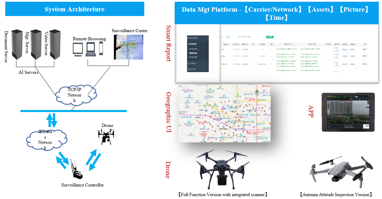
The system consists of a drone, a spectrum scanner, an artificial intelligence analysis and data management cloud platform, and an APP.

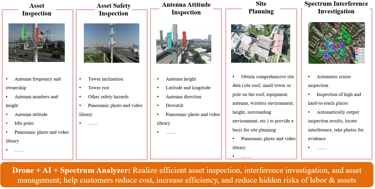
The system mainly provides the following functions:
1. Radio frequency (RF) interference hunting and locating: by planning the automatic cruise path or maneuvering the flight path of the drone, the RF interference source can be efficiently detected, identified and located. The efficiency improvement is more significant when it is used for complex terrain, heavy building environment, or the places that are hard to reach by human being.
2. Asset inspection and inventory: to automatically measures the frequency bands and ownership of the base station antennas, the number and height of antennas, antenna parameters, spare poles, etc., and provide site VR panoramic photos and videos.
3. Antenna attitude inspection: antenna height, latitude and longitude, direction, downtilt angle, photo library and panoramic video.
4. Safety inspection: tower inclination, tower rust and other safety hazards.
5. Site planning: to obtain comprehensive site data (rooftop environment, tower mast, equipment, antenna, wireless environment, height, surrounding environment, etc.) to provide a basis for site planning; provide site panoramic photos and videos.

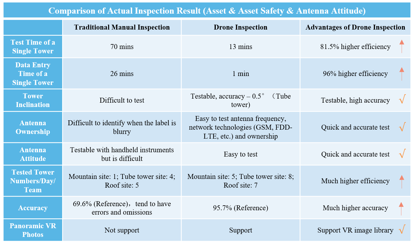
Comparison of Base Station Inspection Efficiency


Related Solutions
Drone-based RF Interference Hunting and Emitter Location Solution
Drone-based Tower and Antenna Asset Inspection Solution
Antenna Alignment Test Solution Based on Drone
Related Cases
Drone-based RF Interference Hunting System Helps an Operator Locate Interference Source in City
Drone-based RF Interference Locating System Helps Find an Illegal Broadcast Station


